
Most, if not all of the ceramics recovered from the Lingga Wreck were made at kilns in Guangdong province, China. During the Northern Song period, the highest quality Chinese ceramics were produced at the Yue, Hutian, and Yaozhou kilns, in provinces well to the north of Guangdong. In many instances the Guangdong potters copied these successful centres. While Guangdong ceramics were generally of poorer quality, they could perhaps compete successfully as the closer proximity of the port of Guangzhou to Southeast Asian markets reduced transport costs. Guangdong ceramics were able to meet the needs of a large segment of the overseas market in which price may have been a primary consideration.
Guangzhou was one of the few main gateways for maritime trade, an emporium for all types of Chinese export ceramics. The port lost this competitive advantage when Quanzhou, in Fujian province, rose to an equal footing during the late Northern Song and eventually came to dominate during the Southern Song. Of particular note, historical records show that the coastal kiln complex at Chaozhou in northern Guangdong was ransacked by pirates during the early Southern Song period. Production was disrupted along with port operations. Indeed, archaeological findings indicate that most of the Guangdong coastal kilns which catered to overseas markets ceased production during the Southern Song period.
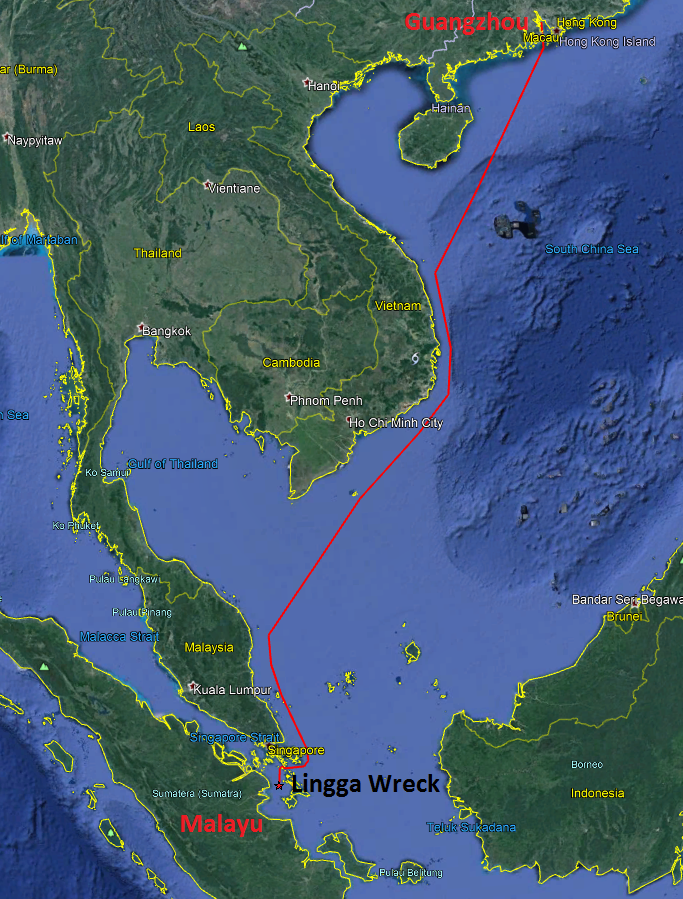
There is little doubt that the Lingga ship loaded her last cargo at Guangzhou. From this port she would have followed the western route down the South China Sea, initially passing between Hainan and the Paracels, turning south having sighted the coast of Vietnam, and then crossing from Con Dao to the coast of Malaysia where the southerly heading was resumed. She may have stopped to take on water and exchange some of her cargo at Pulau Tioman, where archaeological finds include many direct parallels with the Lingga cargo. From Tioman it is not far to the Riau Archipelago.
While considerably more recent, there is a fascinating 17th century Chinese sailors’ song that describes the route south from China, passing Malaysia and entering Indonesian waters:
“… Pahang harbour I would not stay, we come now to Tioman mountain,
Mount Tioman is very bare, but in Pulau Aur we have everything.
There is a shallow bay in Rhio and after passing Pedra Branca
We reach Lingga Straits…” (Lam 1985: 58, from Xiang Daxiao, 1982, Two Books of Compass Charts, Peking)
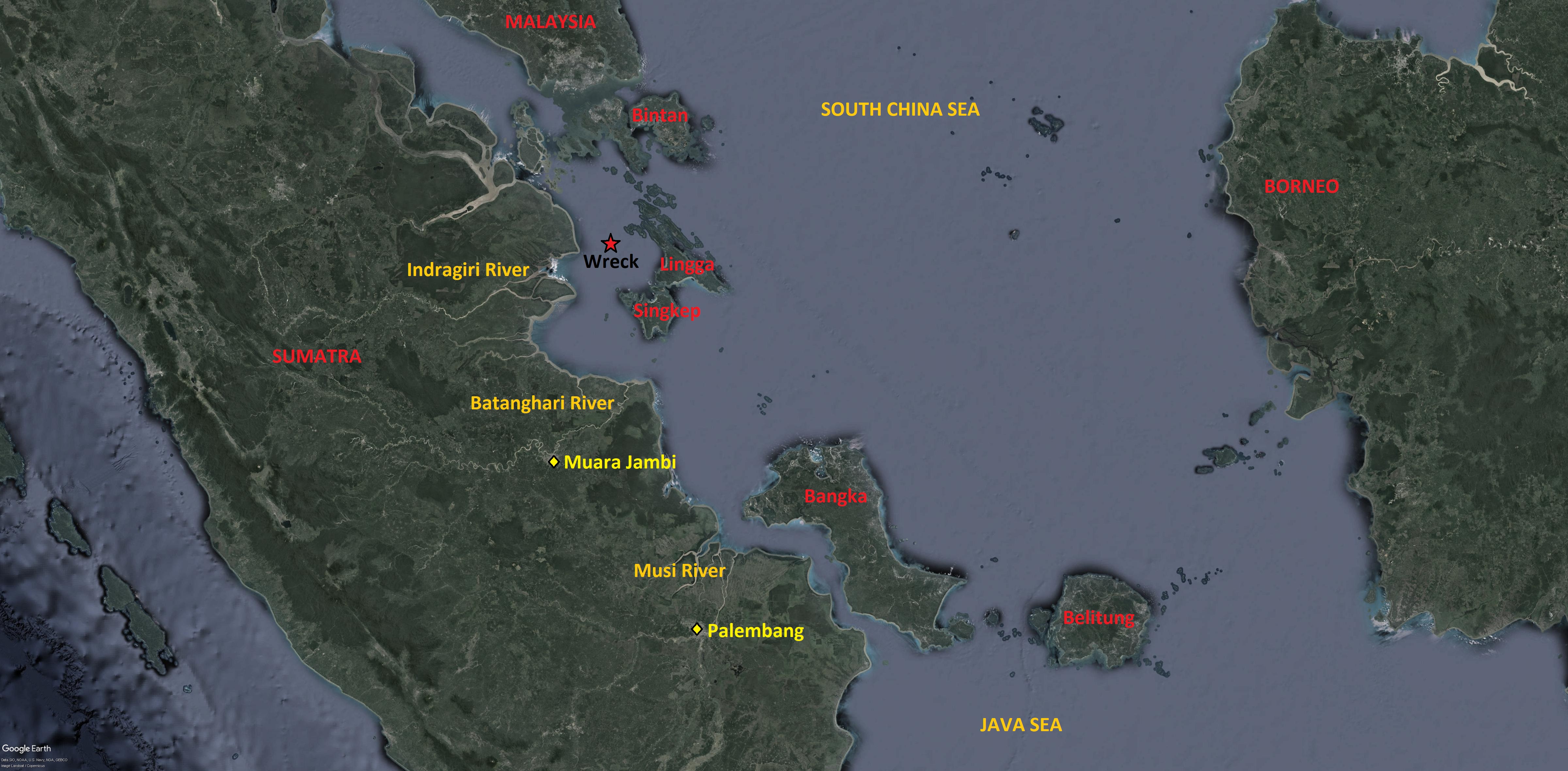
The Lingga Wreck lies in Lingga Strait. Initial speculation is that she was headed for the mouth of the Batanghari River en route to Muara Jambi. Chinese records show that Srivijaya sent ambassadors from Melayu (in Muara Jambi) and from Palembang. They both sent ambassadors in 1079 but Melayu sent two in 1082 and another two in 1088 (Wong 1979). This suggests that Srivijaya declined during this period. The Chola raid in 1025 initiated the weakening of Palembang. Then shifts in trade and allegiances allowed Melayu to displace Srivijaya from the end of the 11th century.
Significant quantities of Song and Yuan period ceramic shards have been found in Muara Jambi, and in nearby supporting riverine ports at Kota Kandis and Muara Kumpeh Hilir. Specifically, shards of folded-rim bowls such as those recovered from the Lingga Wreck and the Pulau Buaya Wreck have been found in quantity at Bangko, in the middle reaches of the Batanghari River. From the archaeological evidence, Edwards McKinnon (1984: 28) concludes that Muara Jambi was a strong religious and economic centre, maintaining political and trading connections with Java, China, Thailand, India, and Arabia. A riverine harbour network linked the capital to inland forests that provided products for the international market, augmenting the well-established entrepot trade.
Had the Lingga ship been heading for the Musi River en route to the original Srivijayan capital, Palembang, it would have been much safer to follow the route to the east of Bintan, Lingga and Singkep. In fact, it would have been much safer to follow this route to get to the Batanghari River, and yet the route to the west of Lingga would seem to have been well established considering the location of the Lingga Wreck and the contemporaneous Pulau Buaya Wreckiii.
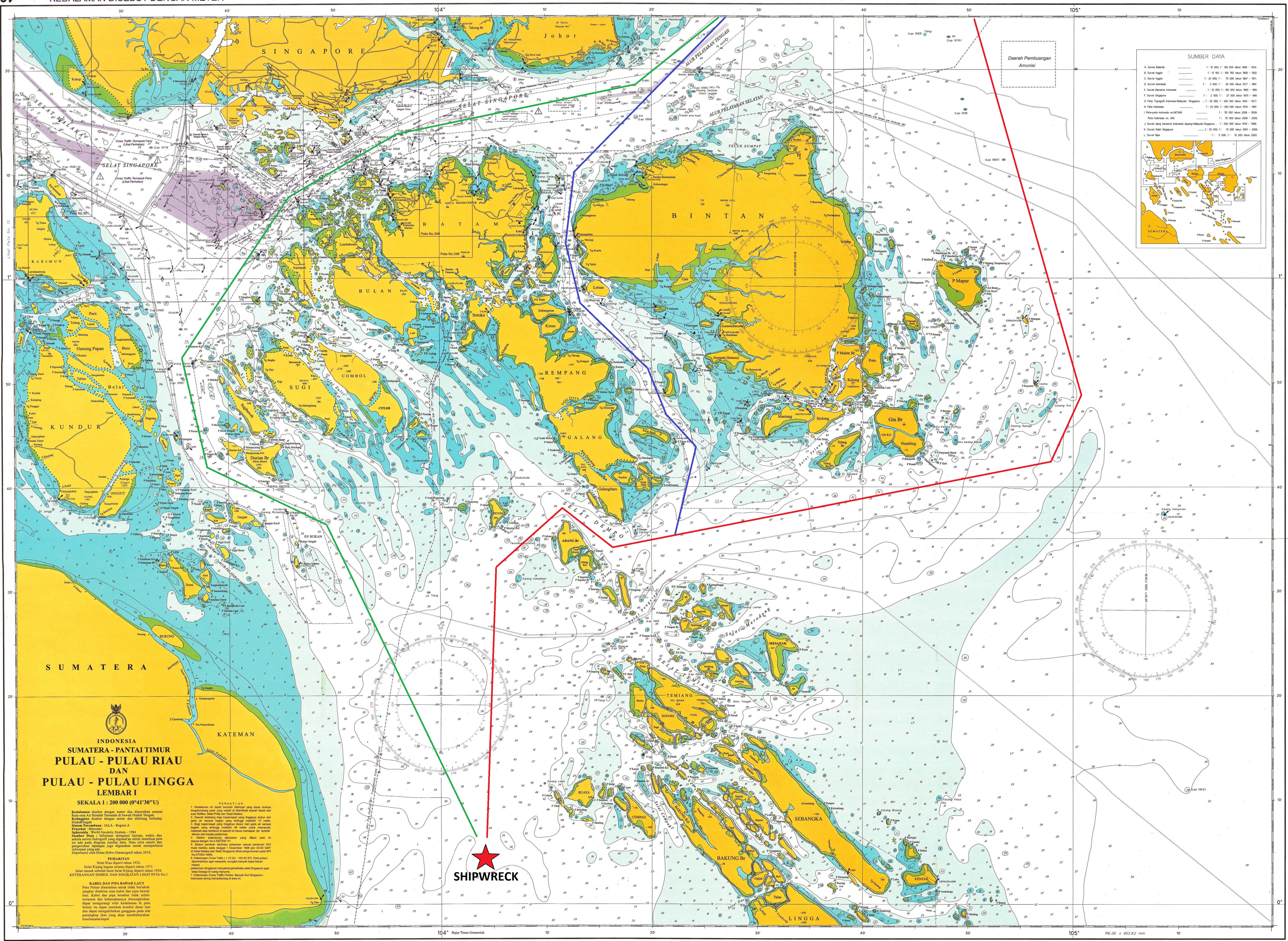
Due to narrow straits, an abundance of reefs, strong and shifting currents, and Sumatra squalls, it is difficult to navigate through the Riau Archipelago, even today. From the modern Admiralty chart and personal experience, rather than any historically researched route, there are only a few options. The least perilous is perhaps to sail east of Bintan before heading west through Dempo Strait, just south of Pulau Galang. Alternatively, a local pilot may have been able to con a ship through the narrow Riau Strait, between Bintan and Batam, before passing west through Dempo Strait. A route westward through Singapore Strait and then south through Durian Strait would also have been feasible, although considerably longer. The seas to the west of Lingga would have been more sheltered than the South China Sea during the northeast monsoon, when these ceramic laden vessels invariably sailed. But as the entire route from China to this point was open sea, there was really no need to take great risks to enjoy a few days of smooth sailing at the end of the voyage. This begs the question: was the ship heading for another, as yet unknown, ancient port? There is another major river system to the northwest of the Batanghari, the Indragiri.
In the late 16th century, the Indragiri kingdom supported Johor in a battle against the Portuguese (Borschberg 2010: 227). During the early 17th century the Portuguese plotted to disrupt the loading of pepper onto Southeast Asian ships off the Indragiri River (Borschberg 2010: 227). The earlier existence of an Indragiri port-city is indeed suggested by its Sanskrit name. The river would seem to have been of some significance before the widespread adoption of Islam in the 15th century. Perhaps there was an important 12th century trade centre on the Indragiri River justifying the hazardous navigation through the Riau Archipelago.
The Lingga Wreck lies in open water, 7 nautical miles from the nearest island. She probably capsized and sank when struck by a localised squall.
iii.The exact location of the Pulau Buaya Wreck is not known, although it does lie to the northwest of the Lingga group (E. Edwards McKinnon, personal communication, November 2017). It was salvaged in the late 1980’s without archaeological supervision.