
The Singapore Cricket Club Excavation:
General Background
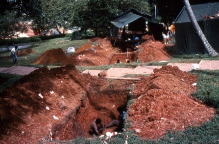
The Singapore Cricket Club (SCC) site was excavated during a period of two weeks in 2003. This project was greatly facilitated by Prof. Brian Farrell of the Department of History, National University of Singapore. As a member of the Singapore Cricket Club, he was able to help the archaeological team to gain permission to excavated a small area (15.2 square meters). Mr. Mark James and Mr. Ray Parry of the SCC were instrumental in enabling the archaeological team to choose a location and a time which would not interfere with the SCC’s regular activities.
Brief History of Archaeology in Singapore
Archaeological research in Singapore began in January 1984. The first excavations were conducted on Fort Canning Hill under the auspices of the National Museum of Singapore and the Parks and Recreation Department (now the National Parks Board/NParks) with financial assistance from Royal Dutch Shell Petroleum. A report was published in 1985 (Miksic 1985). Excavations resumed at Fort Canning in 1987 as part of an ASEAN archaeology project, and continued at intervals thereafter with sponsorship from NParks, the Lee Foundation, the Friends of the Museum ,the Southeast Asian Ceramic Society, and the National University of Singapore. In 1989 a second site, Duxton Hill in Tanjong Pagar, was investigated (Miksic 1989). This was followed by excavations at the Parliament House Complex (PHC - 1996), Empress Place (EMP - 1998), the Istana Kampong Gelam and Colombo Court (IKG and CCT - 2000), Old Parliament House (OPH - 2002), and Bras Basah Park, the National Museum, and the Singapore Cricket Club (SCC) (2003). In 2013, Singapore and the Silk Road of the Sea (Miksic 2013) was published; Chapter 5, “Archaeology in Singapore”, provides a history of archaeological research in Singapore up to that date, including the SCC site.
A general account of archaeological research in Singapore has been published in German (Borell 2001). Specialized reports on local and imported pottery, glass, and metal found in Singapore have appeared in professional journals and books (see bibliography).
History of Precolonial Singapore: A Summary
Singapore plays a major role in the Sululatu’s-salatin, popularly known as the Malay Annals or Sejarah Melayu (SM). The oldest version of this work is found in a manuscript dated 1612, collected by Sir Thomas Stamford Raffles. The SM begins with the launch of a mighty fleet from India with the intent to invade China. Chinese representatives meet the Indian king at Temasek and convince him that his quest is futile. To assuage his disappointment at this turn of events, he explores the sea floor near Temasek, where he meets and marries a princess of an underwater kingdom. After siring three sons with her, he becomes homesick and returns to India. The three sons then appear as grown men in Palembang, Sumatra, where they are acclaimed as kings. One of them, Sang Nila Utama, known after his coronation as Sri Tri Buana (“Lord of the Three Worlds”) sets off in search of a new land. He first arrives on Bintan Island, where he is adopted by the queen as her son. While hunting on the north shore of Batam Island he spies a beautiful white beach across the water, which his subordinates inform him is Temasek. He decides to explore this island, but on his way across the Singapore Strait a fierce storm arises which is only quelled when he throws his crown overboard. Arriving at the mouth of the Singapore River, he spies a strange beast precisely in the area where the Cricket Club now stands. The animal is like none other they have ever seen; it has a black head, red body, and white breast, is about the size of a goat, and has a “noble bearing” (Winstedt 1938: 61). The animal vanishes into the forest and is never seen again. After some discussion, the hunting party decides that the apparition must have been a lion, so they decide to found a new settlement and christen it “Lion City” (Singapura in Sanskrit).
Singapore then becomes a great port and is ruled by five kings. The Javanese kingdom of Majapahit attempts to subjugate it once, but their attack fails. They are invited to attack again by a local treasury official who is embittered because his daughter, the king’s concubine, is unjustly accused of infidelity and shamed in public. The second attack succeeds, but the king, Iskandar Shah, escapes and founds a new port kingdom at Melaka, which also becomes prosperous.
Although the existence of the first four kings cannot be verified, the fifth, Iskandar Shah, appears in Chinese sources of the early Ming Dynasty when a fleet under Admiral Zheng He met him in Melaka. The five kings of Singapore, including Iskandar Shah’s reign in Melaka, together ruled for 114 years, according to the SM. A Ming source says he died in 1413; this would date Singapore’s founding to 1299. There is a discrepancy between the SM and the Ming account regarding a ruler called Parameswara, whom the Chinese record as having been Iskandar Shah’s father; Parameswara is not mentioned in the SM. The general chronology of the SM however conforms to the evidence of the archaeological remains of Singapore.
When the British arrived in 1819, they found a long inscription on a stone at the mouth of the Singapore River. The stone was later destroyed, but studies of fragments of it indicate that the script used was a pre-Islamic type used as early as the tenth century. This is the only written source on Singapore’s precolonial history to have been found on the island, though there is another inscription on the nearby island of Karimun which dates from about the same period, i.e. the tenth century.
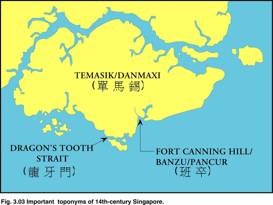
Temasek appears in a court poem of the kingdom of Majapahit dated 1365, which claims Temasek as a vassal (Pigeaud 1960: 11) but provides no other details of the place. The best information about precolonial Temasek/Singapore is found in Chinese sources. A Chinese mission visited a place called the Dragon’s Tooth Strait (Longya men) in 1320 in search of tame elephants. Five years later, Longya men sent a mission to China to declare its loyalty to the emperor. Bintan had sent its own mission two years earlier (Hsü Yün-Ts’iao 1972: 3ff). Most scholars believe that in the fourteenth and fifteenth centuries Longya men was Singapore (Chung Chee Kit 2003).
In 1349 a Chinese merchant with pretensions to scholarly attainment wrote a text for a local gazeteer, Qingyuan xuzhi, "A Continuation of the History and Topography of Quanzhou". Wang’s text, Daoyi zhilue can be translated as "Description of the Barbarians of the Isles" (abbreviated DYZL). He visited Singapore twice in the 1330s. He used the name Danmaxi (Temasek) to refer to the main island and the nearby islets and waterways.) He says that the people of the strait between Labrador Point and Sentosa, which he called the Dragon’s Tooth Strait (Longya men) were bloodthirsty piraates. Chinese ships would rendezvous at Karimun Island before going through the Dragon’s Tooth Strait for safety, and they would prepare to defend themselves against men armed with poisoned blow-gun darts. If they got through the strait safely, they would arrive at Banzu, probably a phonetic representation of the Malay word Pancur, “spring of water”, where there was an honest ruler and a civilized population.
Despite his depiction of the Longya men population as lawless primitives, he also stated that Chinese traded there, and even lived side by side with the natives. This is difficult to comprehend; perhaps he meant to say that the Chinese lived at Banzu. This would make more sense. Wang’s account has been translated several times. Varying translations are compared in Miksic 2013: chapter 4.
At Longya men, Chinese merchants could acquire “coarse laka wood and tin dust”. The local inhabitants wanted “red gold, blue satin, cotton prints, common pottery, iron cauldrons and suchlike things” in exchange. Wang called Banzu “the hill behind Longya men”, and described it as “a convoluted coil” where population lived in houses built on terraces. They made salt by evaporating sea water, and brewed a kind of alcoholic drink from fermented rice. Chinese traders could acquire very fine hornbill casques, lakawood of moderate quality, and cotton, in exchange for green cottons, iron bars, cotton prints, “trade gold”, porcelain, iron pots “etc.”. Wang also reported that Banzu had successfully defended itself against an attack by people from Xian, a word which later referred to “Siam”. Wang’s account suggests that Banzu was located on the hill now known as Fort Canning Hill, and that its society was well-organized.
Malay, Chinese, and early Portuguese sources suggest that Singapore was attacked around 1396, though by whom is disputed. Whereas Malay sources blame Java, the Portuguese heard reports that the attack was actually launched from Patani, a Malay kingdom in what is now southern Thailand. They heard that the motive for the attack was retaliation for the murder of Singapore’s chief, who had been married to a woman from Patani. Patani was a vassal of Ayutthaya at this time; the Thais may have encouraged the Patani people to attack Temasek. The murder was blamed on Parameswara, said to have been a usurper from Sumatra. Parameswara is mentioned in contemporary Chinese sources, but he is omitted from Malay texts, presumably in order to gloss over his usurpation of power in the Singapore-Melaka area in order to preserve the image of continuity of the genealogy of Melaka’s sultans.
Melaka became the new centre of Malay trade in the Straits of Melaka, but Singapore was still an important place. One of Melaka’s heroes, the admiral Hang Tuah, may have been a native of Singapore; his fiefdom was Singapore. Melaka’s main naval strength according to the SM consisted of 40 three-masted cruisers which were based in Singapore. According to the Shunfeng Xiangsung, “Fair Winds for Escort”, which Joseph Needham dated to about 1430 (Mills 1970: 182): “after Ch’ang Yao island [now called Sentosa; it forms part of the Dragon’s Tooth Strait”] had been sighted, the ship ‘on the inside’ passed Tan-ma-hsi strait, where passengers could change ship” (Mills 1970: 325). Thus Singapore was still a transit hub on international maritime sailing routes.
Godinho de Eredia, born in Melaka in 1563, was the son of a Portuguese member of a diplomatic mission to Sulawesi and a Bugis princess, In 1600 he commanded 70 ships which guarded the south end of the Straits of Melaka. In 1604 he founded a fort at Muar and ordered another to be built on Singapore, but nothing came of it. Eredia submitted a report which includes a detailed map of the Straits of Singapore dated 1604 The map indicates that Singapore still had a shahbandar, “lord of the harbour”, probably an official of Johor. The name Xabandaria also appears on at least two other maps from around 1650 (Borschberg 2004: 36). It seems that Singapore had no official government or organized trading settlement for the next 200 years.
A British independent trader, Alexander Hamilton, was offered Singapore to develop as a port by the Malay ruler of Johor in 1703, but he had to decline the offer due to lack of financial means (Hamilton 1930: II, 53). He seems to have inspected the island and found it offered favourable prospects, but mentions no population there. In 1709 a sketch was made by an anonymous hand which shows the entrance to what is now known as Keppel Harbour from the west (the same strait as was known to the Chinese as Longya men) which seems to indicate some houses along the shore. These may have been fishing villages. Singapore appears only as a landmark on navigational maps until the early 19th century. The period from 1604 to 1819 is otherwise almost completely a blank page in Singapore history.
Archaeology of Precolonial Singapore
Thirty years of archaeological research have produced a reasonably detailed portrait of Singapore. Prehistoric artifacts (possibly 4,000 years old, related to Neolithic culture) have been found on Pulau Ubin, northeast Singapore, and Tanjong Karang, west Singapore near Tuas. No excavations have been conducted at these sites. One systematic excavation was performed at Tanjong Bunga, which lies directly across the Johor Strait from Tanjong Karang; only a summary of this research has been published (Tweedie 1953). Some stone artifacts from Tanjong Karang are in the possession of the National Heritage Board.
The next oldest archaeological phase found in Singapore dates from the 14th century. This phase coincides with the earliest confirmed historical references to Singapore found in Chinese and Javanese sources. Discoveries of artifacts from the 14th century are so far limited to the area bounded by Stamford Road, Fort Canning Hill, the Singapore River, and the large public open space known as the Padang. No 14th-century artifacts have been found in nearby areas. Archaeological research in what was formerly Bras Basah Park, now the Singapore Management University campus, Istana Kampung Gelam, and Duxton Hill in Tanjong Pagar, yielded only 19th-century artifacts.
Thirty years of archaeological research have yielded a huge quantity of evidence which is consistent with the conclusion that Wang’s Banzu lay in the area between Fort Canning Hill and the beach as it existed in 1819, before reclamation took place. This area can be divided into two sectors distinguished by topography: one is a hill, the other is flat ground.
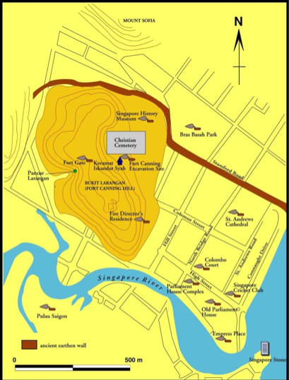
Fort Canning Hill is one sector. When the British arrived in Singapore in 1819, the hill was known as the Forbidden Hill by the local population because according to legend the palace of their ancestors once stood there. Excavations have been performed there since 1984, starting with several test pits around the Keramat Iskandar Shah. Further excavations were conducted at various parts of the hill in 1985, 1987, 1988, 1990, 1991, 1993, 1994, 1995, 1999, 2000, and 2010.
The flat ground between Fort Canning Hill and the sea is the second sector. Five excavations were performed in this area between 1995 and 2003: Parliament House Complex (PHC), Empress Place (EMP), Colombo Court (CCT), Singapore History Museum (SHM), and Old Parliament House (OPH). The Singapore Cricket Club (SCC) was the sixth site in this sector chosen. This was followed in late 2003 by St. Andrew’s Cathedral (STA).
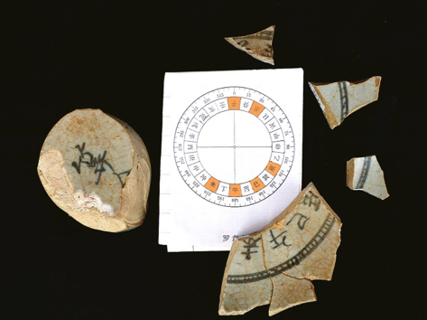
On Fort Canning Hill, the site located on the slope below the shrine known as the Keramat Iskandar Shah (KIS) has yielded some truly amazing discoveries. Foremost among these are the fragments of two objects made of Chinese porcelain:a compass and a porcelain pillow in the form of a model theatrical stage. The model theatre is a rare and complex status symbol used in 13th-century China; no other examples are known to have been exported. The porcelain compass is the only one of its kind known to exist.
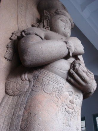
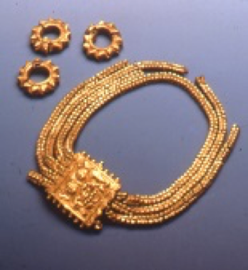
In addition to these extraordinary objects, in 1928 gold ornaments were discovered accidentally on the hillside just above the KIS. These ornaments, now in the National Museum of Singapore, include one with a design of a demon’s head identical to a piece of jewellery depicted on the girdle of a 14th-century ruler of Sumatra, Adityavarman, whose enormous statue is in the Museum Nasional Jakarta.
Other unique discoveries at the KIS site include a large quantity of 14th-century glass objects including over 10,000 tiny glass beads approximately 2 mm in diameter, shards of glass bottles and bowls, fragments of glass bangles, and over 1,000 mis-shapen glass blobs. A few of the blobs are stuck to sherds of Chinese porcelain. A few shards of similar bottles, bowls, bangles, and beads have been discovered at Si Pamutung, a site in the highlands of West Sumatra (Perret ), but no blobs. A dense concentration of charcoal next to the spot where the glass items were found can be interpreted as evidence that the shards were being recycled into bangles at the site. The discovery of many broken beads indicates that the beads were being strung or sewn to some other material at the same location (Miksic 2017a). Research at the Department of Physics at the National University of Singapore indicates that the chemical formula used to make the glass used for the beads and shards was made in China. Chinese glass of the 14th century is rare; only one glass workshop of this period has been found in China, and that workshop did not produce such elaborate glass as the Fort Canning examples.
In addition to these discoveries which are unique in the annals of archaeology, over 25,000 items dated to the 14th century layer found at the KIS site have been catalogued. None of them can be dated later than 1400 with the possible exception of two fragments of a glazed ceramic covered box. Some Chinese coins dating to the Tang dynasty (618-906) have been found, but these were almost certainly imported to the site during the 14th century. No other Tang items have been found at KIS. Some of these items include scraps of gold foil, small clay cups probably used as crucibles, and Chinese bottles probably used to contain mercury. These taken together point to the conclusion that gold was being worked at this site. It is therefore logical to infer that the KIS area was used by palace craftsmen working for the elite of Singapore who lived further up the hill.
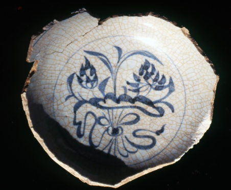
The vast majority of artifacts found at the KIS site are replicated at the other 14th-century sites found on the plain southeast of Fort Canning Hill between the Singapore River, the Esplanade, and Stamford Road. These include Chinese porcelain which at this period consisted of three main types according to color: green, white, and white decorated with blue painted designs. These main types can be broken down into smaller categories. The best examples of the green porcelain have a blue-green color often termed celadon. Some of the white porcelain also has a bluish tinge which is called qingbai in Chinese. Sherds of the white ware also display differences in thickness and hardness which may indicate different qualities or locations of production. Of all 14th-century sites in Southeast Asia, only KIS has yielded sherds of blue-painted white pottery which is probably not made in Jingdezhen. Much of the glaze of this pottery has flaked off, indicating a poor fit between glaze and clay body; the style is painting is much simpler and cruder than the Jingdezhen examples. Its origin is a mystery. It may have been made in Yunnan. There are also a few sherds of white ware decorated with brown spots of iron, or red designs using copper. Beyond these differences of color, there are other traits which can be observed such as decorative techniques (molding, underglaze incising, stamping, etc). Shapes and sizes form another dimension which can be measured.
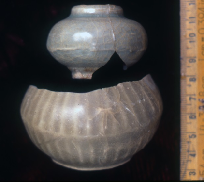
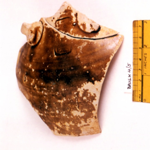
Stoneware is a second major category of artifacts found throughout 14th-century Temasek sites. Scholars differ on the proper meaning of the term porcelain. In this series of reports, “porcelain” is used to refer to ceramics with clay bodies which have been or were meant to be completely vitrified. Vitrification occurs when a piece of pottery is heated to a temperature sufficient to melt all the clay particles (usually around 1300°–1500° C). When the pottery cools, it forms a solid with no gaps or spaces between the clay particles, thus becoming non-porous. When struck, a good piece of porcelain will ring like a bell. This quality seems to have been particularly sought after by Southeast Asians, according to ethnographic sources. Green porcelain was valued in some cases because it was thought capable of changing color on exposure to poison. Porcelain can be coated with thick layers of glaze producing a surface as smooth as glass. Porcelain was mainly used in the 14th century for decorative items such as vases, jarlets, cups for wine, bowls, and covered boxes possibly used to contain cosmetics, and plates.
Stoneware is defined as ceramics which have been heated to a temperature at which the surfaces of most of the clay particles melt, a process known as sintering. This occurs at temperatures between 900° and 1200° C. Stonewares are semi-porous, and can be decorated with glaze, though its appearance is less shiny and uniform than that of glazed porcelain. Stoneware objects are less dense than porcelain. Stoneware was mainly used for large storage jars and basins. Potters sometimes added coarse material such as sand to the clay of stoneware in a process called tempering. This technique was used to ensure that the density of the clay was as uniform as possible, and that water in the clay body could escape during the drying process. Ceramics had to be as dry as possible before firing; any water trapped in the clay could explode when it boiled, spoiling the ceramic piece.
All the porcelain and stoneware found in 14th-century Temasek was made in China. In the 15th century Singapore began to import small quantities of porcelain and stoneware from Vietnam and Thailand. Only one Thai artifact, a covered box from the kiln complex of Sawankhalok, has been found on Fort Canning. The other examples of Thai and Vietnamese ware were all found on the Singapore plain. No 15th-century Chinese artifacts have been found on Fort Canning. This indicates that Fort Canning was probably abandoned around 1400. This date coincides with the move of the Malay capital from Singapore to Melaka according to Chinese and Malay historical sources. People continued to live on the Singapore plain, however, as historical sources and archaeological discoveries both confirm.
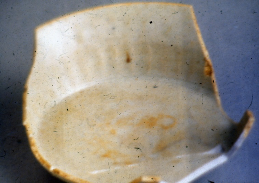
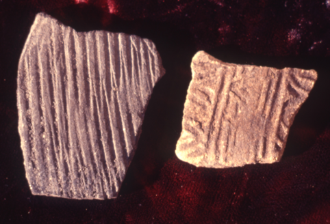
Earthenware is the third important category of ceramics. This consists of clay objects fired to a temperature below 900°C. At these temperatures, clay becomes hardened through the loss of water, but no physical change takes places in the clay particles. Earthenware can be glazed by using lead as a flux to lower the melting point of the sand from which glaze is made. Lead glazing was conducted in China, and in West Asia too. A few examples of lead glazed pottery were also made in Trowulan, capital of 14th-century Majapahit in east Java. Earthenware was almost certainly made in 14th-century Singapore. A 19th-century British source reports that excellent clay for pottery-making was found in Bras Basah. No remains of pottery-making equipment have yet been found in Singapore, but the probability that most of the earthenware found in Singapore was locally-made is very high. The majority of the local earthenware was decorated with a technique known as carved paddle impression. A flat piece of wood was carved and the surface of the clay vessel under construction was lightly beaten with it, thus transferring the design to the clay. Earthenware made with this technique is commonly found in archaeological sites from south Thailand (the Patani area) throughout the southern Malay Peninsula, all over Sumatra, and in western Borneo and western Java.
Earthenware was used for a variety of purposes. Most of the sherds found in Singapore represent storage vessels and cooking pots. Drinking water was often stored in an ewer of a particular shape termed kendi in Malay. Kendis have long vertical necks, ovoid bodies, circular feet, and pointed spouts on the shoulder for pouring the water out. Earthenware’s porosity was advantageous for this function; due to earthenware’s porosity, water could seep outward through the pores between the clay particles, and evaporate on the outer surface of the kendi. This had the effect of lowering the temperature of the water inside the kendi.
Earthenware can be divided into numerous types. Dimensions of variation include size, shape, decorative motifs and techniques, color, and also the type of temper used, including coarse, medium, or fine particles. Earthenware pottery can be tested by the use of techniques such as spectroscopy and petrography to determine where it is likely to have been made. Some earthenware pottery found in Singapore stands out from the rest of the sherds due to its lack of temper, its smooth almost soapy surface texture, its white or pink color, and its common use for making kendis. Chemical tests of this ware performed at the National University of Singapore Physics Department laboratory showed that it was probably imported from southern Thailand, where deposits of very fine clay exist. Examples of this southern Thai fine paste ware have been found in Sumatra, Malaysia, and on shipwrecks in Riau and the Java Sea.
Excavations in Singapore (summary)
| Year | Site | Area |
|---|---|---|
| 1984 | Keramat Iskandar Shah (KIS) | Fort Canning |
| 1987 | different sites | Fort Canning |
| 1988 | Fort Canning (FTC) | Fort Canning |
| 1989 | Duxton Hill | Tanjong Pagar |
| 1990 | Fort Canning | Fort Canning |
| 1992 | Percival Steps | Fort Canning |
| 1994 | Fire Director’s Residence | Fort Canning |
| 1994 | Parliament House Complex (PHC) | Singapore Plain |
| 1998 | Empress Place (EMP) | Singapore Plain |
| 2000 | Fort Canning | Fort Canning |
| 2000 | Istana Kampong Glam | Kampong Glam |
| 2000 | Colombo Court (CCT) | Singapore Plain |
| 2001 | Singapore History Museum & Bras Basah Park | Singapore Plain |
| 2002 | Old Parliament House (OPH) | Singapore Plain |
| 2003 | Singapore Cricket Club (SCC) | Singapore Plain |
| 2003 | Saint Andrews Cathedral (STA) | Singapore Plain |
| 2010 | Fort Canning Spice Garden | Fort Canning |
Why the SCC Site Was Selected for Excavation
The archaeology of Fort Canning Hill has been relatively well documented. Most of the excavations there have been targeted at the area around the Keramat Iskandar Shah. This is due to the facts that this area is the richest in terms of number and quality of artifacts so far found anywhere in Singapore, that the soil structure there provides an excellent example of archaeological stratigraphy, and that the National Parks Board has been very supportive of archaeology, including the allocation of space to store artifacts found on the hill, and funding to create a permanent outdoor display on the site in order to educate the public about the importance of Fort Canning in Singapore’s precolonial history. Other parts of the hill have been sampled. Some show very little potential for yielding precolonial artifacts due to natural topography or colonial and recent landscaping. Others have considerable potential for future research. Some areas have not been sampled, mainly due to restrictions on access to areas near the service reservoir.
Excavations at PHC, EMP, CCT, SHM, and OPH conducted between 1995 and 2002 were undertaken as the result of construction work. In each case, it was possible to obtain permission from the site owners to carry out excavation between the demolition of the previous structures and the construction of new buildings. No strategy was involved; as sites became available, which were about to be destroyed, they were investigated in whatever length of time was allowed by the contractors’ schedules.
The previous sites excavated in the Singapore plain sector all lay near the Singapore River. Each of these sites displayed different characteristics. At PHC, much evidence of copper working was uncovered. At OPH, many large fragments of artifacts were uncovered, including 12 intact stoneware bottles of a type termed “mercury ware”. Archaeologists differ among themselves regarding the use of these vessels. The only contents ever found in any of them consist of traces of calcium, probably lime made from seashells used in chewing betel when mixed with areca nut and other condiments and rolled up in leaves. It is probable that these bottles were reused for many purposes. They were so common in 14th-century Temasek that they could be casually discarded even if they were perfectly intact. Examples have been found in other sites in the region, including Pengkalan Bujang in Kedah, Malaysia, and Kota Cina in north Sumatra. The arguments in favor of the hypothesis that they were designed originally to contain mercury are summarized in Miksic 2013, as well as other theories such as one which holds that they were meant for wine.
At EMP, the site excavated lay between the high and low tide marks. This area seems to have been a place where boats were moored, and cargo loaded and unloaded. At CCT and NHM, not enough artifacts were recovered in undisturbed contexts to determine what the main activity/activities at those sites may have been.
In the case of the SCC, no construction was contemplated, but through the intercession of Prof. Brian Farrell alluded to earlier, permission was granted during a brief interval when no other use of the playing fields was scheduled. The SCC site gives a glimpse of what may lie beneath the entire Padang, a large area where no major buildings have ever been constructed. In 2003, we did not know whether all human activity was concentrated along the Singapore River, or whether it extended further northeast, toward Stamford Road. According to British descriptions of the early 19th century, an earthen embankment ran from the seacoast all the way to the base of Fort Canning Hill, parallel to a stream known as the Fresh Water Stream. At the foot of Fort Canning Hill near the spot where the National Museum is today, the Fresh Water stream’s course ran northeast, to its source on Mount Sophia, while the embankment turned northwest, up the slope of Fort Canning.
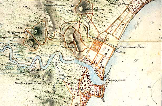
1822 map of Singapore, depicting the “Old Lines of Singapore” or Malay Wall, the Fresh Water River, and other locations mentioned in the earliest British accounts of Singapore. Source: British Library M XII 35 Plan of the Island of Singapore including the new British settlement and adjacent islands. The settlement environs, New Harbour, and adjacent islands surveyed by Lt Col Farquhar etc.
The Singapore Stone inscription was found on Rocky Point. The green presently called the Padang is termed Parade (short for Parade Ground, a military term). Four square structures are depicted on the northwestern fringe of the Padang beside St. Andrew’s Road. At this time the road only extended as far north as the junction with what is now Coleman Street. It is not known what these buildings served. They may have been soldiers’ quarters. This would explain their regular alignment and size It is possible that the structure closest to the junction with what is now known as High Street stood on or near the site of the excavation in 2003. Another map drawn in 1819 depicts a “Line of Officers’ Tents” in this same area; see frontispiece to Miksic 2013.
The British called the embankment the Old Lines or the Malay Wall. Sir Stamford Raffles equated it with the wall which protected Singapore from an attack by the Javanese according to the SM. Its existence is also alluded to by Wang Dayuan, who records that the people of Danmaxi (Temasek) “shut up their gates” when they were attacked by the Xian (“Siamese”) around 1330. They were able to keep the Xian from breaking through the wall for a month, after which the attackers withdrew. If this formed the northeastern boundary of the settlement, it would be logical to expect to find archaeological remains between the river and Stamford Road. This was the main question which the excavation in April 2003 was meant to answer. A secondary line of inquiry was represented by the desire to know more about the distribution of various uses of land in Singapore, the density of occupation in the 14th-century settlement as a whole, and the range of artifacts found in the entire site.